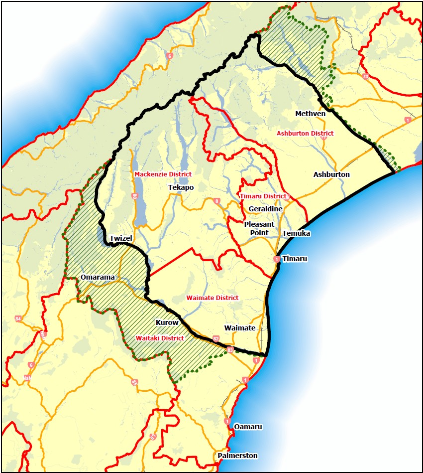
 A Mid-South Canterbury Unitary Council based on either territorial or river catchment boundaries
Size (Territory)
19,607 sq km
Population: (approx)
100,900
GDP: (approx)
$8.4 billion
Council Assets: (approx)
$4.3 billion
This option would create a new
unitary council covering:
- Timaru District;
- Waimate District;
- Mackenzie District; and
- Ashburton District.
And optionally (extended part of map)
- the Rakaia River catchment
currently within Ashburton and Selwyn Districts; and - the Waitaki River catchment currently
within Waitaki, Waimate and
Mackenzie Districts.
This option would bring together four districts with a combined population of just over 100,000 people, providing more scale and capability than Option A while still offering a reasonably coherent Mid-South Canterbury model.
| Possible Advantages | Possible Disadvantages or risks |
|---|---|
| Creates a larger organisation than Option A, with greater scale and capability. | Larger boundaries may make some communities feel more distant from decision-making, and local voice arrangements would need careful design. |
| Better aligns local and regional functions in one council. | Some regional functions, especially river and freshwater management, may still require crossboundary arrangements. |
| May provide stronger long-term planning for infrastructure, land use, freshwater, transport and economic development than current arrangements, although with less scale than the larger options.. | Detailed arrangements for assets, debt, staff, services and representation are not yet known. |
| Gives local councils and communities more influence over the shape of reform than waiting for the backstop process. | There may be transition costs before any efficiencies are achieved. |
| Could reduce some duplication between district and regional council functions over time. | Using only territorial boundaries would leave some river and catchment management issues to be managed through cross-boundary arrangements, including for the Waitaki River. |
| Ashburton’s strongest links may differ across communities, with some connections north toward Greater Christchurch and some south toward Timaru. | |
| Agreement would be needed with other councils and the Government. |
Including river catchments (highlighted in green)
- This option also recognises that some regional council functions, such as river management, flood protection
and freshwater management, work most logically across catchments rather than existing district council boundaries. - Including the Rakaia and Waitaki catchments could reduce the complexity of shared river management and provide a more integrated approach to environmental and infrastructure planning.
- This would add the additional cost of river management in these areas which may not be fully met by rates from the number of rating units gained.
- Including parts of existing neighbouring districts would add complexity, and local voice arrangements would need careful design.
- There will be boundary, rating, asset and debt-splitting issues that would arise from including parts or Selwyn and Waitaki Districts in any final model.
Other options:
Option A: A South Canterbury Unitary Council based on either territorial or river catchment boundaries
Option C: A Mid-South Canterbury & North Otago Unitary Council based on either territorial or river catchment boundaries.
Option D: Do not submit a Head Start proposal and enter the backstop process.
Option E: Other option – You may prefer another arrangement.
Last updated: 24 Jul 2026