In this section
Making our Communities Safer: Identifying Timaru District's Priority Buildings
Council is seeking feedback on the proposed priority thoroughfares and strategic routes as part of the process of identifying Timaru District’s priority buildings.
Why are we doing this?
The Building (Earthquake-prone Buildings) Amendment Act 2016 introduced a new system of identifying and managing earthquake-prone buildings.
Some buildings are automatically categorised as priority buildings based on their purpose (e.g. hospitals, emergency response services such as police). Other buildings may be identified as priority buildings due to their proximity to priority thoroughfares and strategic routes and their potential for failure in an earthquake. To identify these other priority buildings, we must first identify priority thoroughfares and strategic routes.
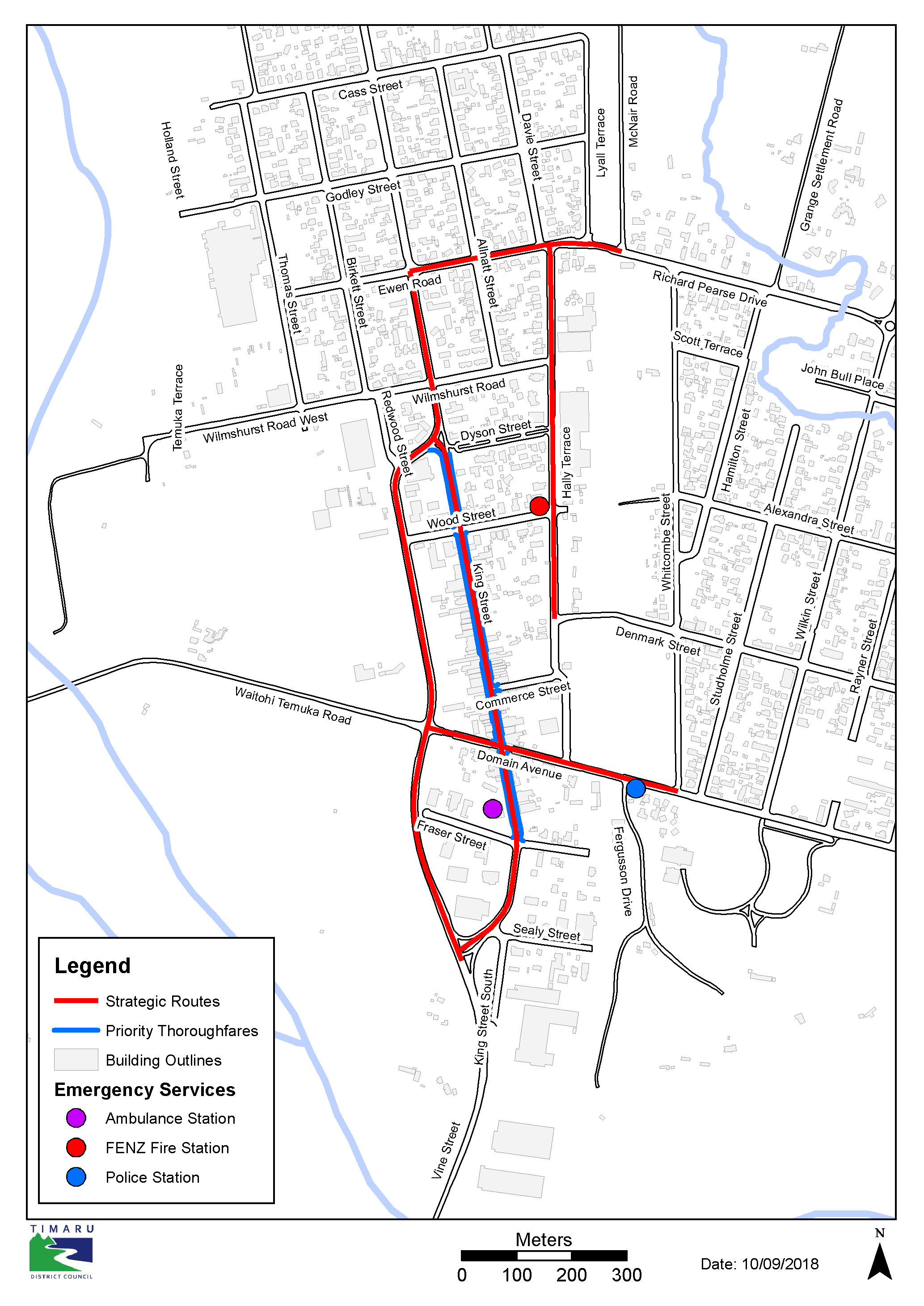
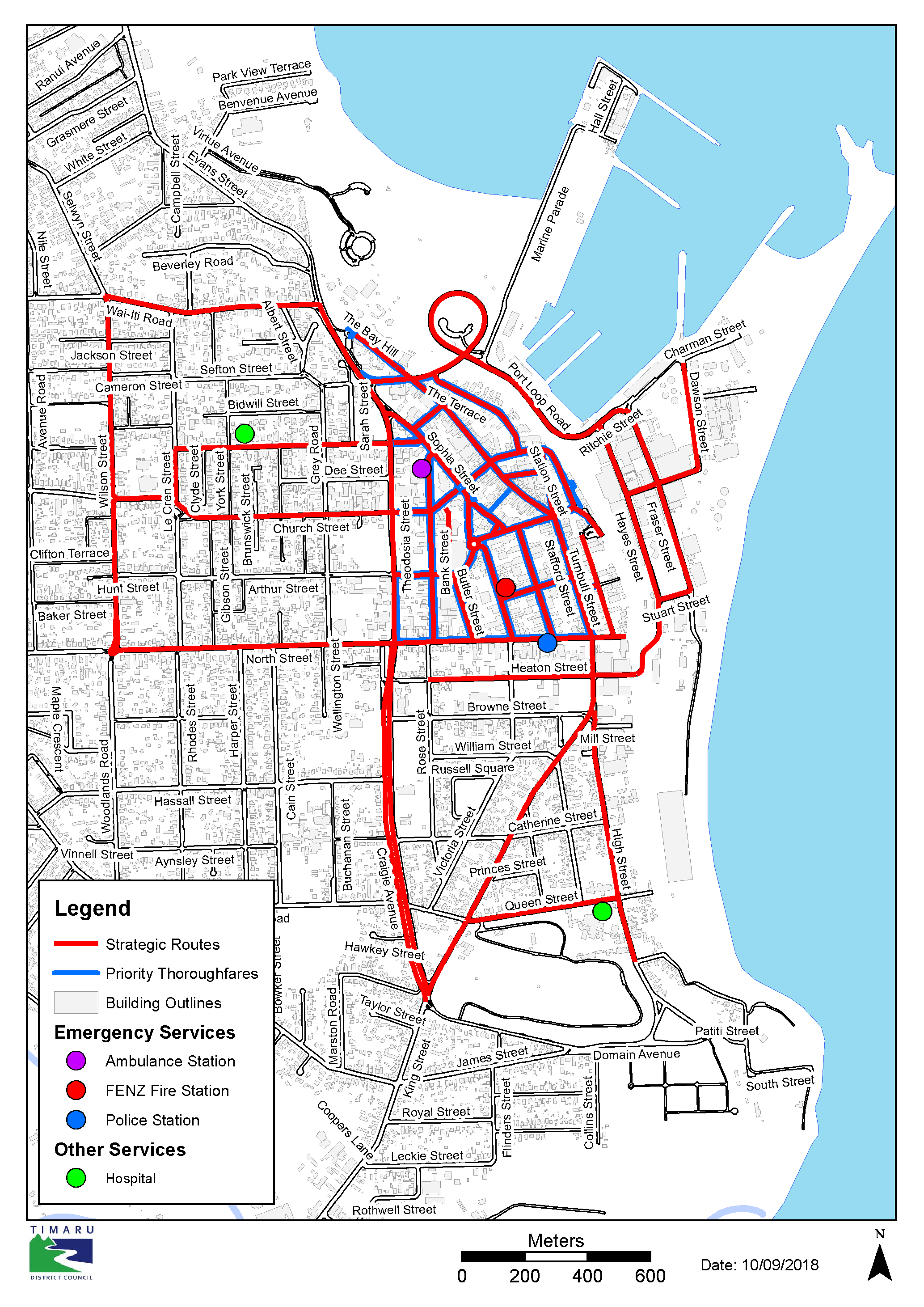
A Priority Thoroughfare may be prioritised if it is an area with high pedestrian and vehicle movements, and is at risk if an Unreinforced Masonry Building (URM) was to collapse on it during an earthquake.
A Strategic route may warrant prioritisation if the route would be blocked should a URM collapse on it during an earthquake, preventing emergency response. These strategic routes are routes for emergency services to gain access after an event, and are essential for a number of reasons, most importantly saving lives. Buildings impeding a strategic transport route in an earthquake could delay an emergency response to the detriment of the community (i.e. loss of life, if access to emergency care is not possible).
If a building is classified as a priority building, it must be remediated in half the timeframe of other earthquake-prone buildings under the Act (i.e. 12.5 years).
What is being proposed?
The maps below show the proposed priority thoroughfares and strategic routes throughout the district’s key communities. These areas have been proposed due to the higher concentration of Unreinforced Masonry Buildings (URMs) in relation to strategic routes and priority thoroughfares. A number of criteria have been used to identify these areas.
We are seeking your feedback on the following questions:
- Do you agree with what we have proposed?
- If not, which priority thoroughfare or strategic routes do you disagree with and why?
- Are there any other priority thoroughfares or strategic routes that you think meet the criteria, but are not listed?
How to have your say
Submissions have closed. Thanks to those who gave us your feedback. You can read the submissions and Officer Comments on the submissions received here.
Please note your submission will be available to the public and media as it will be part of the Council’s decision-making process. If you need any assistance, please contact Council at (03) 687 7200.
Submissions close 5pm, Monday, 29 October, 2018
Timelines
| 27 September 2018 | Submissions Open |
| 29 October 2018 | Submissions Close |
| 27 November 2018 | Council Hearing (if required) |
| December 2018 | Final Decisions |
Frequently Asked Questions
When did this law come into effect??
The new law came into effect on 1 July 2017 with an amendment to the Building Act 2004.
Why are we consulting on this?
Section 133AF of the Building Act 2004 requires Council to consult if a territorial authority contains an area of medium or high seismic risk and to identify priority thoroughfares and strategic routes.
What are the timeframes for identifying and strengthening in the medium seismic zone?
Timaru District is in the medium seismic zone. Timeframes are:
| Priority Buildings | Other Buildings | |
|---|---|---|
| Council must identify potentially Earthquake-Prone buildings by: | 1 July 2022 | 1 July 2027 |
| Owners of Earthquake-Prone buildings must carry our seismic work within (timeframes apply from issue of an EPB notice): | 12.5 years | 25 years |
What does Earthquake-Prone mean?
A building, or part of a building, is Earthquake-Prone if it will have its ultimate capacity exceeded in a moderate earthquake, and, if it were to collapse, would do so in a way likely to cause injury or death to persons in or near the building or on any other property, or cause damage to any other property.
What happens once final decisions are made?
Once priority thoroughfares/strategic routes have been finalised, Timaru District Council will look at buildings on those thoroughfares to determine whether they are potentially earthquake prone in accordance with the EPB methodology#.
What does this mean for me as a Building Owner?
Affected building owners will be notified. Owners of potentially Earthquake-Prone buildings, whether a priority building or not, have 12 months to provide an engineering assessment. Timaru District Council will then determine whether the building is earthquake prone, and notify the building owner of this decision.
What does this mean for me as a resident?
As a resident, this process is part of changes designed to make communities safer, particularly in the event of an earthquake.
# The EPB methodology is a regulatory tool that sets out the types of buildings that Council must identify as potentially earthquake prone.
Definitions
It may be helpful to understand a few terms that are referred to here and in the legislation.
- Earthquake-Prone Building (EPB): A building built prior to 1976 that, after an assessment by a structural engineer, is found to have a rating lower than 34%NBS.
- New Building Standard (NBS): The %NBS figure describes the degree to which an existing building on the site would perform when compared with a new building designed to meet the seismic ratings that existed on 1 July, 2017. For example, a building built in 1927 that is rated as 20%NBS, means it would meet 20% of the current seismic building standard, whereas a new building in the same place would be 100%NBS (or more).
- Priority Buildings: Certain buildings in high and medium risk seismic areas are considered to be of greater risk due to their type of construction, use or location. They need to be identified and remediated in half the timeframe of other buildings, (i.e. 12.5 years). Further guidance on priority buildings is available at: https://www.building.govt.nz/managing-buildings/managing-earthquake-prone-buildings/resources/
- Priority Thoroughfare – An area with high pedestrian and vehicle movements.
- Remediation: When a building is assessed and found to have all or parts of the building below the minimum 34%NBS, building owners can deal with this by either strengthening those elements to exceed the minimum rating, or remove that element or all of the building.
- Strategic Route – a route deemed of strategic importance which if impeded may lead to an inability to provide an emergency response
- Unreinforced Masonry Buildings (URM): Generally a building that has no additional reinforcing elements, often with parapets, facades, verandas or balconies facing a road or footpath.
Links
- Building Act
- Managing earthquake-prone buildings - (Ministry of Business, Innovation and Employment - MBIE)
- Video - Introducing the system for managing earthquake-prone buildings (MBIE)
- Timaru District Council Earthquake-Prone Buildings webpages
Last updated: 12 Apr 2021