Published: 13 Dec 2019

As of 2.56pm on 13/12/19 Nigel Bowen, the Mayor of Timaru District has officially ended the State of Local Emergency for the Flooding in the Rangitata Area.
The EOC will be transitioning from response to recovery mode, where we work to provide the advice and services to help get the community back to normal.
Free water testing for Rangitata Zone residents
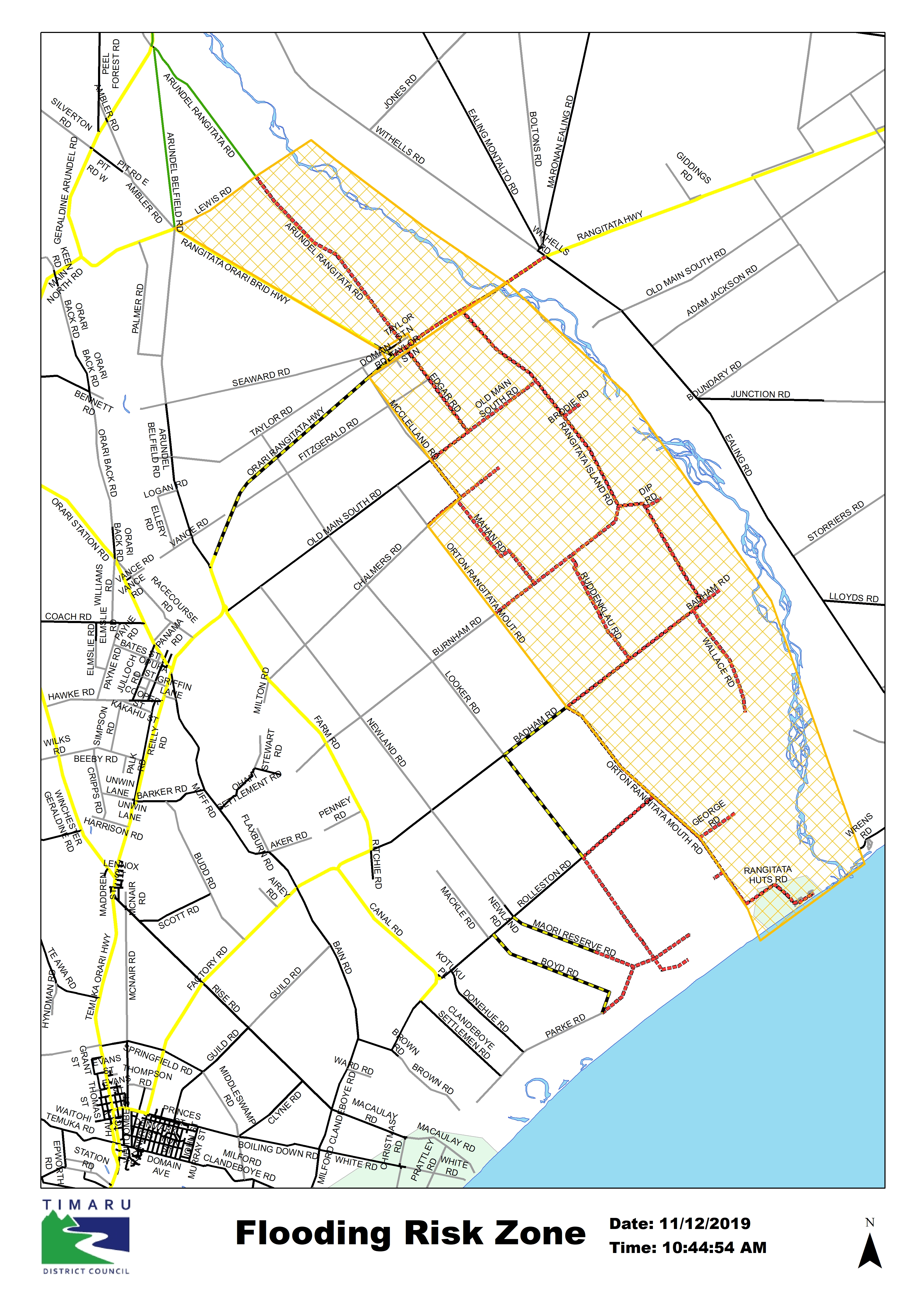
Timaru District Council is offering free water testing for properties within the Rangitata Flood Risk Zone.
One free water test will be offered to people in the flood risk zone between Monday 16 December and Wednesday 18 December. All people need to do is phone the council on 03 687 7200 to book a test.
Timaru Civil Defence Controller Tracy Tierney said that offering these tests was one small way the council could help.
“People working on farms throughout the area will have many things to worry about, but ensuring you have safe source of drinking water is critical so this is one small thing we can take care of.
“The tests will give a quick indication of whether the water coming out of your tap is up to standard to use for eating, drinking and preparing food.”
----------
12/12
This is our morning update about the emergency response to the Rangitata River flooding prepared at 10.30am on Thursday 12 December.
ECAN is continuing to stem the flow through the south branch and other river works, but the current situation remains extremely changeable. The river remains unpredictable and with little to no flood defence is prone to further breakouts, especially if there is further wet weather.
The previously marked Evacuation Area has transitioned to a Flood Risk Zone. This will allow access to the area, but please be aware highly vulnerable to flooding and will continue to be vulnerable for the foreseeable future.
Anyone entering the area must ensure they make a full risk assessment. Risks will include, but are not limited to:
- Risk of flooding – Flood waters could move or increase with little warning, ensure that you know where you and anyone you have with you is, and ensure that you have a clearly defined evacuation route.
- Flood water on roads – this may be deeper and faster flowing than it looks, please do not take unnecessary risks.
- Electricity – Please treat all power lines as live.
- Hygiene and sanitation – all flood water must be assumed to be contaminated, contact and ingestion could make you sick, so please avoid where possible. When working in the area ensure you wash your hands before drinking or eating.
- Access to fresh drinking water – it may be easier to bring in drinking water as water from the local tapped private supplies carries a contamination risk within the flood zone. There are no Timaru District Council drinking water supplies in the area, so if using a private water supply or bore in the area for drinking, preparing food please boil for at least one minute.
- Staying aware – Ensure you have some form of communication. Connect with the Timaru District Council Facebook for Civil Defence updates. Non-facebook users can still see the info at www.facebook.com/timarudc
People in the Flood Risk Zone will need to remain vigilant, and ready to move at short notice. Power and water may be cut-off with no notice.
Currently the level of Rangitata River continues to drop slowly, but unfortunately this does not mean that the flooding event is over or that there not be more significant impacts.
Water movements can be unpredictable over this period.
State Highway 1 across the Rangitata Bridge reopened last night. Speed restrictions are in place so PLEASE keep your speed down and follow speed limits and any road crew instructions.
The Inland Route 72 diversion has been removed. Two way traffic is now allowed across the Orari Bridge has resumed. Southbound traffic must give way to Northbound as per usual.
The Emergency Operations Centre is remaining active as part of the ongoing response.
Please call Timaru District Council on 03 687 7200 for anything you need and we can coordinate for you. This can be for your any concerns you have relating to your situation.
RIVER FLOWS
- River conditions both in the main branch and the south branch of the Rangitata River remain highly changeable
- It is not unexpected after this level of flooding that the river will continue to scour out and enter other low areas. This is leading to new flow patterns
- Flows are receding slowly but significant flows are ongoing.
WHAT’S BEING DONE ABOUT IT?
- Environment Canterbury staff and contractors are working flat-out in the river at Arundel and upstream of State Highway 1
- Heavy machinery is being used to divert flows above the break-out point but this will take some time while the river levels are still high
- We are aware of rumours regarding farmers or contractors carrying out works that may be causing overflows. This is not the case. The works being carried out on the river banks are to contain outflows.
WHAT SHOULD PEOPLE DO?
- PLEASE REMAIN VIGILANT WITHIN THE FLOOD RISK ZONE! We can’t afford to become complacent as river levels drop – conditions are extremely dynamic and flood waters still poses a major risk
- Those entering the Flood Risk Zone should undertake a full risk assessment and be aware of the risks as mentioned above
- The situation remains changeable so please regularly monitor updates and follow the instructions of emergency services and traffic control in the area. If you are feel unsafe or at risk, please do not wait for notification, even if your house had been given clearance by the response team yesterday.
- If you are in immediate danger, call 111.
- Look for the latest information @Timaru District Council and follow the instructions provided
- We completely understand the frustration that this is causing. This has been a major event for the district and we’ve got a long way to go yet.
Electrical Supplies
Power services may be cut unexpectedly due to changing water flows:
- If you are in the Flood Risk Zone, please remain vigilant and ensure you can evacuate if needed.
- If flooding threatens turn off any sensitive electrical equipment at the wall, such as computers, modems, fax machines and media players. Otherwise, please ensure your equipment is protected against power surges. Note that as long as fridges and freezers are kept closed, the food inside shouldn't be affected.
- Protecting anyone in your home that has critical medical equipment powered by mains electricity, or is reliant on electricity for critical medical support. If the disconnection of electricity may result in loss of life, or serious harm to you or someone in your home, you will need to ensure that you have an emergency response plan in place to respond to this electricity outage.
- Protecting yourself. Please remember to be careful and treat all lines and equipment as live at all times. Your power may be restored without warning and possibly earlier than planned.
- Occasionally there may be events or circumstances beyond our control which may prevent the planned outage(s) from occurring, or may cause the interruption times and dates to vary. We apologise for any inconvenience should this happen and, where possible, will endeavour to adhere to the timeframes outlined in our communication.
Flood affected properties
Our response and welfare teams have been visiting properties in the flood affected area yesterday and will continue to do so today. We know this can be a stressful time, but we’re here to help you access services, resources and help you get back home safely.
One of the first steps we take is a rapid visual assessment of your property. If there are signs that there has been flood water in the property a yellow advisory notice will have been attached.
As a local authority it’s our legal duty to ensure that your house is safe for you to be in.
Yellow placards (or yellow stickered buildings) attached to your building mean that this has been assessed by a building officer as being in need of further attention, and they have given you restricted access to your house.
This restricted access means that you can remove items, dry out the inside, undertake any repairs and clean up. This access does not allow you to sleep or live in the house as it may be unsafe to do so.
Remember that we’re here to help, we’ll be keeping in touch but if you have any queries you can us on 03 687 7200 tomorrow.
For rural properties The Rural Support Trust can help you access further government support for rural communities, you can contact them on 0800 787 254.

Current Confirmed Road closures have been applied to the following: PLEASE NOTE THERE WILL BE SIGNIFICANT SURFACE WATER ON ALL ROADS. THIS COULD BE DEEPER THAN IT LOOKS. PLEASE DON'T RISK IT.
- Old Main South Road - Closed
- Burnham Road, Rangitata - Closed
- Badham Road, Rangitata - Closed
- Looker Road - Closed

Helping flood affected residents
If you’ve been affected by flood water in your house, our teams are ready to help you.
Timaru District Council Building and Welfare staff have initiated support and assessments to ensure that people can stay in their homes safely, identify any needs they may have and answer any building related queries.
We have visited flood affected properties yesterday, and will continue to do so today, but if there are any concerns or urgent queries, people can ring 03 687 7200 24 hours a day or visit Temuka or Geraldine Library and Service Centres or the Timaru District Council Building.

Rapid Building Useability Assessments
The Timaru District Council Building Team will be activating the Rapid post disaster building usability assessments.
If you have had flood water in your home or it has been hit with debris it needs to be checked to ensure it continues to be safe to occupy. This will also cover issues such as ensuring septic systems are working properly.
This is focused on houses during this initial period, but will then capture industrial or working buildings.
Depending on the number of flooded homes this may take some days to undertake, but we’ll be prioritising this work in the recovery period.
If you have suffered flooding through your home, please contact civil defence ops on 03 684 8624 and don’t forget to contact your insurer.
--
OLDER MESSAGES
Timaru Civil Defence in monitoring and welfare phase overnight
This is our late evening update for 8/12/19, there will be no further information issued until tomorrow. Our Facebook page will be taking a short break overnight, council enquiries can be made to our main phone line.
The Timaru EOC will remain open overnight to monitor the status of the river, and is prepared to fully reactivate if the situation requires.
State Highway 1 at Rangitata and the Upper Rangitata Bridge at Arundel (Inland Route 72) remain closed until further notice.
Our roading contractors have put up the floodlights and are working through the night to start re-establishing the inland route 72 at Upper Rangitata Bridge. We’ll have a progress update in the morning. If everything goes to plan over the next 24 hours priority will be initially given to essential supplies and recovery teams.
This road remains closed until further notice. Please do not pass the cordons to leave space for heavy machinery and supplies to get to the work site. It’s best to go back to Timaru.
There is accommodation still available in Timaru or on sites like airbnb, and a welfare centre with emergency accommodation has been opened at the Southern Trust Events Centre, 70 Morgans Road, Timaru.
If you are in areas outside the Timaru District we would advise that you stay put.
More details will be published tomorrow on this facebook page or at Timaru.govt.nz
Have a safe night everyone.
--
The Rangitata River is flow is currently dropping slowly, the two river crossings are likely to be closed for the next 36 hours.
Work will be beginning as soon as possible to restore the necessary north south link at Arundel.
Timaru Civil Defence is prioritising the upper Rangitata bridge crossing as it will see water levels drop to a manageable level hours before the downstream bridge at State Highway 1.
Timaru Emergency Operations Centre Controller Justin Bagust said the district roading contractors were now assembling heavy machinery at the southern approach to the road to be ready as soon as the water levels subside.
“We’re aware of the importance of the north south link and by prioritising this route we can hopefully have a passable solution for people as soon as possible.
“It still remains a dynamic situation, and we can’t give any indication of a timeline at the moment, but we’ll have updates as soon as we can.
“We’d ask people to stay where they are at the moment and not to drive up to the bridge, as it will still be some time before we have any progress and we need to ensure access for heavy vehicles and supplies.
“Please check the TDC website and Facebook for further updates.”
GERALDINE IS VERY BUSY - TRY TIMARU
We’ve had an update from Geraldine that the town is extremely busy and access to facilities is being significantly stressed.
- There is currently no access to eftpos or cash machines in Geraldine at the moment as the data networks are down.
- We would recommend that people travelling from out of the district head down State Highway 8 to Timaru where there are more facilities available.
09.00h - 7/12/19
Forecasts have changed overnight and extreme rain has fallen in the upper catchment of the Rangitata River with around 300 mm recorded so far Friday and Saturday morning. The forecast is for further rain until 1 pm Saturday followed by a brief lull and the potential for more rain overnight Saturday.
The River is currently flowing at around 2140 cumecs at the gorge recorder and is rising rapidly. Extreme flows, likely 3000 cumecs or more, are anticipated later on Saturday. Flow may reach the highest peak for the last 20 years.
Some floodwater is currently flowing down the South Branch, and there are several other vulnerable areas along the river that are at risk of river breakouts. The extreme flows expected today will increase outflows into those areas already flooding as well as increase the chance of issues developing on other parts of the river.
This extended period of very high flows increases significantly the risk of further bank erosion and breakout flows.
River flow patterns can change quickly as a result of these high, changing flows and landowners with stock in low-lying areas should shift stock to higher ground.
Widespread flooding is likely. Please use extreme caution and ensure your own safety as the situation could change throughout the day.
Environment Canterbury staff are monitoring the river and we will update with further information as the situation changes.
There is indication of further heavy rainfall in alpine catchments later on Saturday and into Sunday.
07.00h - 7/12/19
The Timaru Emergency Operations Centre has activated this morning in response to flooding of the Rangitata River. Updates will be posted here and on the TDC Facebook when we have them.
-
This message is recorded at 6:45 am Saturday 7th December 2019.
Forecasts have changed overnight and extreme rain has fallen in the upper catchment of the Rangitata River with around 300 mm recorded so far Friday and Saturday morning. The forecast is for further rain until 1 pm Saturday followed by a brief lull and the potential for more rain overnight Saturday.
The River is currently flowing at around 1550 cumecs at the gorge recorder and is rising rapidly. Extreme flows, likely 2500 cumecs or more, are anticipated later on Saturday. Flow may reach the highest peak for the last 20 years.
Some floodwater is currently flowing down the South Branch, and there are several other vulnerable areas along the river that are at risk of river breakouts. The extreme flows expected today will increase outflows into those areas already flooding as well as increase the chance of issues developing on other parts of the river.
This extended period of very high flows increases significantly the risk of further bank erosion and breakout flows.
River flow patterns can change quickly as a result of these high, changing flows and landowners with stock in low-lying areas should shift stock to higher ground.
Widespread flooding is likely. Please use extreme caution and ensure your own safety as the situation could change throughout the day.
Environment Canterbury staff are monitoring the river and we will update with further information as the situation changes.
There is indication of further heavy rainfall in alpine catchments later on Saturday and into Sunday.
--
The Timaru District Civil Defence team are currently monitoring river levels of the Rangitata River following significant rainfall in the headlands.
This extended period of very high flows increases significantly the risk of bank erosion and river breakouts, including into the South Branch.
Main areas of concern are currently upstream from Arundel Bridge at the South Bank including Ferry Road and Arundel Bridge Reserve: WE DO NOT RECOMMEND OVERNIGHT CAMPING AT THIS SITE.
River flow patterns can change quickly as a result of these high, changing flows and landowners with stock in low-lying areas should consider shifting stock to higher ground.
This message will be updated when the situation changes
River flow and rainfall information can be found here:
Road Closures:
- Burnham Road between Rangitata Island and Orton Rangitata Mouth Roads
- Old Main South Road between Edgar and Rangitata Island Roads
Advise Caution:
- Ferry Road at Arundel
TIMARU DISTRICT CIVIL DEFENCE: RANGITATA RIVER
16.30h - 4/12/19
The Timaru District Civil Defence team are currently monitoring river levels of the Rangitata River following significant rainfall in the headlands.
This extended period of very high flows increases significantly the risk of bank erosion and river breakouts, including into the South Branch.
Main areas of concern are currently upstream from Arundel Bridge at the South Bank including Ferry Road and Arundel Bridge Reserve: WE DO NOT RECOMMEND OVERNIGHT CAMPING AT THIS SITE.
River flow patterns can change quickly as a result of these high, changing flows and landowners with stock in low-lying areas should consider shifting stock to higher ground.
This message will be updated when the situation changes
River flow and rainfall information can be found here:
Last updated: 24 Feb 2021